This is "Onbekommerd"!

Friday, June 22, 2012

Maasholm.

We are back at the mouth of the Schlei. Well, almost: at the actual mouth, there is a harbour called Schleimünde, which is small and in a bird sanctuary but also very unprotected from strong winds. As we were expecting some bad weather and also needed to to some shopping, we stopped in Maasholm, which is just a mile or two short of the mouth but is well protected and has (as we have discovered) one small 'supermarket'.

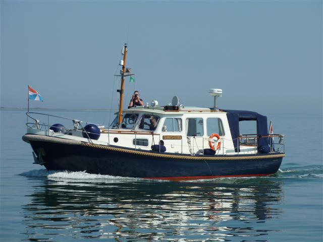
At the start of the 20 odd mile trip, we still saw some signs of Vikings:


There is an abundance of jellyfish here in the harbour. The neighbours think they are a pest, but Lyn got this nice shot:


We may leave tomorrow morning, but quite possibly we'll stay another day. The next port is likely to be Sønderborg, our first Danish port. That will require a Danish SIM card for the iPad as well as Danish Kroner (they don't use Euros). Arriving on a Saturday afternoon may not be the best option in respect of that and also the weather on Sunday morning may be a bit better. We'll decide tomorrow morning, but if there is no blogpost for a few days, it may well be because we are without an Internet connection. I must say that the German T Mobile card has served us exceptionally well, we have had excellent connections since Greetsiel on 31 May. The only problem has been that it blocks VOIP, so no Skype. We hope to get a good solution in Denmark as well.

Thursday, June 21, 2012

The Vikings at Hedeby

Between 1200 and 1000 years ago, there was a town called Hedeby, at the end of the Schlei, just across from the present day Schleswig. It was a Viking town, built to facilitate the trade between the Baltic and the North Sea. This is because from this place it is only 18 KM to the Treene river which, via the Eider river runs into the North Sea. It is therefore the easiest trade route, bypassing the long and dangerous sea route around Jutland. An ideal place to build a trading post. Between 870 and 1050, Hedeby grew to be the biggest city in North Europe. In 1050, and again in 1066, the town was sacked and eventually totally destroyed. The town of Schleswig was built a few KM North of its site. Rising waters destroyed what remained and the existence was completely forgotten until the 20th century, when archeological excavations unearthed very significant amounts of Viking artefacts, building materials, graves and even a complete Viking ship. There now is a very interesting museum nearby and on the actual site of Hedeby, a number of Viking houses have been reconstructed.


We cycled to Hedeby from our berth at Schleswig, a 6KM ride. It is midsummer's day today, 21 June, and it was sunny and relatively warm (maybe 20C). When we got back, the wind started to get stronger, up to over 20 Knots (6 Bft). We had already planned to stay here. Tomorrow we'll go down the Schlei again, probably to Maasholm and from there see when the weather is suitable to go to our first Danish port.

Wednesday, June 20, 2012

Schleswig

It took three and a half hours to calmly motor up the Schlei to the 'end', at Scheswig. There has been a settlement here since 840 BC. The best landmark now is the 'Dom', the cathedral. Even the pilot tells you to head for the Dom, once you get to a certain mark (80 / Haddeby 1, to be exact).

From that mark, it looks like this:


And this is the inside of the Dom:


As many of the towns here, Schleswig has a 'pedestrian area', which means a street full of shops. This is useful when you need supplies, but otherwise not very attractive.
On the other hand, there are also streets like this:


We have not seen any Vikings yet (see yesterday's post), but there is a Viking Museum a short cycle ride away, which we'll visit tomorrow.

Location:Am Hafen,Schleswig,Germany

Tuesday, June 19, 2012

Kappeln

After spending a day in Laboe, we did our first 'Baltic crossing' today. It was a nice quiet day, very little wind and a sea that was for the most part pretty flat. We set course to Schleimünde, the mouth of the Schlei, which is a fjord-like river or a river-like fjord, depending on which pilot you read.
First you pass Kiel lighthouse:


And some 20 miles later, in a NW direction, you get to the Schlei lighthouse:


We motored on to the town of Kappeln, an old fishing town turned quite touristy. You tie up right on the towns quayside:


As you can see, we are quite far North, we were a bit more East yesterday: Laboe is at 10 degrees 14 minutes East.


One of the attractions of Kappeln for the boating fraternity is a shop called Prätorius. If you prove you are on a boat (with your official Certificate of Ownership), you can enter an area where you can buy low cost beer etc. With prices of alcohol sky high in Scandinavia, many boats stock up here. So we joined the trend:


Tomorrow, we plan to move up to the 'head' of the Schlei, the town of Schleswig, which has a Viking history.

Sunday, June 17, 2012

Baltic!

This morning, we started (after buying 150 l of diesel) with the second part of the Kiel Canal. The shipping was a bit busier than yesterday, at one time we met a convoy of 4 big ships:


A bit after midday, we got to the lock at Kiel Holtenau. There was a one hour wait and then we finally moved into the Kieler Förde, the entrance (for us) to the Baltic. Immediately, the atmosphere changes, even the colour of the light is a bit different, it seems. This is the first impression:


As it happens, it is Kiel Week, the biggest regatta week in Europe. Not only are there lots of races, for classes from Optimists to 60 foot yachts, it is also a big sailing spectacle with participation of numerous square riggers as a highlight. We had to manoeuvre our way through all sorts of craft (including ocean going vessels on their way to Kiel or the locks).


Although it is very busy in all ports around here, we managed to find a place in our 'first choice' marina in Laboe, a fishing town at the mouth of the Kieler Förde. We went for a walk and found a fruit stall on the market where we bought an entire basket full of fruit for €10 (including the basket itself!). We'll be having lots of 'smoothies' the next few days. We tend to buy fresh food at least every 2 days and live quite healthily as a result.


We will stay here tomorrow and plan to go North thereafter.

Location:Fördewanderweg,Laboe,Germany

Saturday, June 16, 2012

Rendsburg

When we left Otterndorf at 9:30 this morning, the plan was to go through the lock at Brunsbüttel at the beginning of the Kiel Canal and spend the night there. But we are in Rendsburg. That is 60 KM further, and a day ahead of our non-existent schedule. So what happened?
We left Otterndorf and got onto the Elbe, taking advantage of the ongoing tide. The traffic of big container vessels was a lot less than expected, we met a very big one, which caused a 2m surge wave and a few smaller ones. Just before 11 we got to the waiting area for the lock, and half an hour later the indication came (an interrupted white light) that we were allowed to enter the lock. This is a serious canal, run by serious Germans, using serious rules! The lock is huge, and it has small floating jetties to tie on to, making the whole process quite uncomplicated:
Fortunately, there is a separate lock for pleasure craft, you don't have to share it with some of the seriously big ships that use the canal.
By 12, we were on the canal and headed for the small yacht harbour. This was quite busy, did not look attractive and was right next to the entrance of the 'new locks', where big ships go in and out 24 hours a day. Now that may be interesting / exciting for a few hours, but not through the night. So we decided to continue the 66KM to Rendsburg, the first reasonable opportunity to tie on for the night. The canal is quite interesting: now and then a big ship, which does not cause a lot of hassle quite a few ferries crossing the canal and quite a few yachts going in either direction. Sometimes, these all come together:
And then there are the bridges: the canal has several bridges, some from the time it was dug (1885 to 1895) and some much newer. Most are 42 m high! This is a particularly nice railway bridge:
But the most spectacular one is the railway bridge at Rendsburg, which also carries a 'suspended ferry'.
The 'cage' that hangs below the bridge and slides to the other side in a few minutes even carries a few cars!
I wonder if there is anything like this elsewhere in the world?
Soon after this bridge we turned off the canal and a few miles later tied up at the Rendsburg Yacht Club. We have some washing to do tomorrow morning, thereafter we plan to do the last 40KM of the canal to the Baltic and spend the night at one of the marinas at the Kieler Förde.
Friday, June 15, 2012

Otterndorf

We are in Otterndorf, on the river Elbe. After one night without tides, this is tidal again, with a drop of about 3m.

From Berdekesa it was a 4 hour trip to the Otterndorf lock, which - like the other 2 locks on the Elbe - Weser waterway - has guillotine doors: they open upwards and not sideways. In this picture you can see the lock door behind Lyn. After the lock door there is an arched bridge to make it more interesting!


As you can see, the mast is down here: the bridges on the canal were as low as 2.7 m and with our mast we are 5 m. With the mast down we are 3m and if we drop the radar antenna and the searchlight too, we get down to 2.5 m.

Otterndorf is not all that interesting. It's a 45 min walk to the supermarket. But its a useful point to wait for the right tide either up- or down the Elbe. Tomorrow we leave around 10 am to catch the ongoing tide to Brunsbuttel and the entry to the Kiel Canal.

Location:Medemsand,Otterndorf,Germany