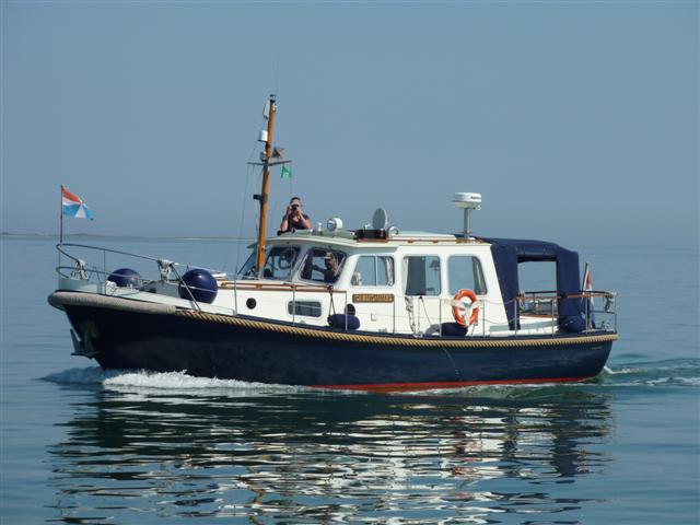
This is "Onbekommerd"!

Friday, June 17, 2016

A strategic stop

We are now in Västervik. This is a 'strategic stop' for us for two reasons. Firstly, there is a very good supermarket in this nice town and in the next week we will be in little bays and on small islands with little or no option to get supplies. So we stocked up today. And secondly there is a lot of rain forecast tonight and tomorrow (it has just started raining).

Yesterday was also rainy, but not a downpour. We decided to stay in Klintemåla, where we now we're the only 'guest boat'. That was clearly not enough to get the harbourmaster to make an appearance: we had a free night.

The trip from Klintemåla this morning was nice. We are now in the skärgård proper, you make your way around the little rocks and islands guided by buoys and little lighthouses that look like huts for pixies:


Close to Västervik, you go through the Sparö channel. It is quite narrow (but not the narrowest we have ever been through) but quite deep, about 6 metres at the shallowest point).


In days gone past, the waters here were unmarked: King Valdemar did not want his enemies to know where the rocks were. And also the pilotage business, which was owned by the Crown, was an attractive source of income!

In just over 4 weeks, since we left the Netherlands, we have covered some 650 miles. The people from a Dutch yacht whom we have seen regularly since Ystad told us today it is now 196 miles to Mariehamn on the Åland Islands. That's sort of their destination and ours too. Back in Ystad it was 450 miles to go, and we look forward to the next bit which promises to be fun with the Midsummer celebrations next week and a visit to Stockholm thereafter.

We'll keep you informed!

Location:Notholmsvägen,Vastervik,Sweden

Thursday, June 16, 2016

The lonely German yachtsmen

We arrived in Klintemåla yesterday. It's a very small and very scenic 'harbour', part of a community of mainly holiday homes built straight onto the rocks.


Yesterday we lit the Cobb, our view from the on-shore table was this:


There was only one other visiting boat and he is the reason behind the title of this post.
We quite often meet German yachts with only one person on board. This is not a new thing, in our previous visits to Sweden it has occurred regularly. They are always very friendly men who are happy to have a conversation. When we asked one of them if he would not prefer to have his wife on board, the reply was : "Sure I would, but German wife's are not like Dutch or English, they don't like to be on board for a long time". Now we have also seen German yachts manned by (presumably) happy couples, so maybe there is a bit of a generalisation in the remark of that skipper but the fact remains that we see quite a few of these lonely souls (who sometimes hope that their wife will join them for a week or two).

In the meantime it's rainy today and as we have a bit of time in our 'schedule' (bringing us to Nävekvarn for the midsummer celebrations on the 24th), we have decided to enjoy the solitude (the lonely German has just left) and award ourselves a rest day.

Location:Klintemåla,Oskarshamn,Sweden

Tuesday, June 14, 2016

Into the 'skärgård'

We are now in Figeholm, the 'entry point' of the 'skärgård', the archipelago on the east coast of Sweden. This was our first 'aim' of this year's trip, so we are pretty happy with the progress.


From here we'll work our way North, in between thousands of (mainly) very small islands, often not more than just a rock. Most of the 'open sea' work has now been done, at least for a while. Every now and then one may have to cross a bay or so, but nothing like 'looking for the land'.
Today we did the last bit of that, from Sandvik on Öland (where there was not sufficient Internet for a blogpost) back to the mainland. On the way we crossed paths with the high speed ferry from Gotland. As it is difficult to estimate what the course of a high speed vessel will be (a change of course of a few degrees makes a big difference), we called the ferry on the VHF and negotiated with the duty officer how we would cross courses. All very efficient also thanks to the AIS which gives us the call sign and name of the vessel.

We often tie onto low jetties here and Onbekommerd's bow is quite high, making it difficult to get on and off. To help with this, we followed the Swedish example and acquired a 'bow ladder':


Very smart, we think!

Ultimately, we would ,like to go to the Åland Islands this year. That is still quite a way to go and there is a special chart folio for it. As the Åland Islands are a semi autonomous part of Finland, the charts are in Finnish (but with Swedish and English notations as well, fortunately)


Location:Smedjegatan,Figeholm,Sweden

Sunday, June 12, 2016

Kalmar

A final picture of Kristianopel, the church in Danish style with both the Danish and Swedish flags flying.


This is because Kristianopel was a border town (on the Danish side) between Sweden and Denmark until 1653. Now it is at the northern end of the Swedish province of Blekinge.

When we left Kristianopel this morning for the almost 30 mile trip to Kalmar, there was little wind, but as we got further north it picked up to maybe 15 knots. Not a lot, but enough to get salt on the boat again.

Arriving in Kalmar is always a bit special as you are greeted by the castle:


Kalmar is a useful stop, as a big town it has good shops and also the least expensive diesel in Sweden (that is the accepted wisdom at least). So we filled up with 289 litres....

It is interesting that in every harbour you meet a 'core' of boats that are doing the same route as you are. A mixture of a few Dutch and a few more German boats. One tends to become quite friendly: 'how was your trip?', 'what are your plans for tomorrow?', 'what is are your further plans this year?'.

Sort of a big happy family, travelling North. Sometimes someone skips a place, only to rejoin later. It's nice!

Location:Landgången,Kalmar,Sweden

Saturday, June 11, 2016

Into the Kalmarsund

We spent an extra day in Karlskrona and in really nice weather got into the Kalmarsund today.
First you go through the 'skärgård' (archipelago) of Karlskrona, which is very pretty:


There are some narrow channels to navigate. They are all well marked with red and green buoys and in addition sometimes with 'leading lines', beacons on shore which guide you along the channel by keeping the one in line with the other:


After the skärgård bit, you pass Torhamns Udde en get into the Kalmarsund which is open water again. The wind was light and we only got an occasional bit of spray over the bows of Onbekommerd. Three hours later we were tied up in Kristianopel, a small harbour which we like a lot. No wonder when this is the view from the front deck!


As the weather was nice (although a bit colder than before yesterday's cold front), we lit the Cobb and had drinks on the rocks whilst cooking our meat:


Just a reminder: if you click on the 'location' at the bottom of each blogpost , you will get a map showing our location.

Location:Karlskrona,Sweden

Thursday, June 9, 2016

High school graduation day

After a nice calm trip from Hanö, we arrived in Karlskrona around midday.


We took advantage of the excellent facilities in the renovated harbour to run two loads of washing. Next we went into town to do some shopping. It transpired that today is the day that the high school students get the results of their final exams. We have seen that before in Denmark as well as in Sweden, it's a big celebration. Here in Karlskrona, the successful students sit in the back of trucks (all wearing sailors' hats) and get driven through the town. Hundreds of people, parents, siblings and many other members of the community line the streets and cheer them on. They themselves blow hooters and make a lot of noise. Presumably some alcohol flows, but at 4:30 when we witnessed all of this, that was not all that obvious. It was all very festive!


Location:Skeppsbrokajen,Karlskrona,Sweden

A small Swedish island

From Simrishamn to Hanö is about 30 nmiles, 5 hours motoring. We once again left early (6am) as the predictions were that there would be a 20 knot+ wind from 5pm onward. And even if that would come earlier we wanted to be tucked away in a harbour.
After three and a half hours the wind picked up a bit (it was not the planned easterly but a westerly wind) and the waves came exactly side-on , which is uncomfortable. So we headed up a bit and an hour later could run straight before the waves to Hanö. It took 20 minutes longer that way, but it was very much more comfortable. Those who look on marinetraffic.com will have seen the strange track, hence the explanation.

Hanö is a really nice little island, only 2.2 sq kilometres big. It has a lighthouse on the highest point which is 55m above sea level. We walked there.


On the way down we passed the 'English cemetery'. During the Napoleonic wars, England had a Navy base here and a few sailors were buried on the island.


On the way down to the harbour we found the only car on the island. It is no longer in an operable condition:


The 20 knot wind eventually arrives as predicted at 5pm from the East. It's calm now and it is predicted to be fine tomorrow for the next leg to Karlskrona.

Location:Sweden